It has been a wet year so far in the low Pampas of South America. Northeast Argentina and the adjacent parts of Paraguay, Uruguay and Brazil have been hit with extensive flooding.
Since the beginning of the year, the area has received about five times the long-term expected average rainfall.
On January 8, the Argentine city of Resistencia recorded 224mm rainfall. This is a new 24-hour rainfall record, much higher than the previous highest of 206mm, recorded in January 1994.
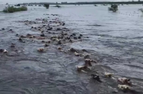
Eastern Pampas has good farming land but the first soybean crop was a complete loss in some areas because of the rain. The ground is still water-logged. In the province of Corrientes, water is nearly two metres deep, displacing the herds of cattle.
In Paso de Los Libres, a border city in what is known as the Argentine Mesopotamia, January brought 483mm of rain so far. The average rainfall for January is 128mm.
The likely reason for this excessively wet spring and early summer is the state of the Pacific. The forecast from the end of southern hemisphere winter gave a 90 percent chance of El Nino conditions developing. Warm water did flood the eastern equatorial Pacific, but in the last month has drawn back a little.
There is now a 65 percent chance of a proper El Nino developing, according to the National Oceanic and Atmospheric Administration (NOAA), and it is El Nino conditions that tend to disrupt the normal rainfall pattern in this part of the world. The Atacama Desert in Chile benefits from El Nino rains, but the Peruvian fishing industry suffers.
Even though the Pacific waters are not much warmer than usual at the moment, it may be the driving force behind the current weather conditions. The forecast for the next week suggests another 250mm of rain in the Argentine province of Corrientes and the northern parts of Uruguay.Source: aljazeera.com
Comments